Protecting our Estuary for future generations.
Introduction
The State of the Exe Estuary toolkit is an online resource which provides easy access to the information available on the current status of the Exe Estuary. This information enables us to see how the estuary has changed over the years, by comparing the present condition of the estuary with the condition of the estuary captured within our past State of the Exe reports, which can be accessed below:
The reports highlight changing pressures, natural processes, varied uses and quality of the estuary, and how they interact with each other. The issues highlighted through the State of the Exe Estuary are used to underpin the objectives in the Exe Estuary Management Partnership’s Management Plans. Stakeholders will be able to make use of this information to make informed decisions to manage the Exe, benefitting the estuary and its users. Delivery of this framework of management is undertaken by various bodies who coordinate their activities through the Exe Estuary Management Partnership, details of which can be found on our Partners page.
Special thanks go to Local Councillors Jeffrey Trail BEM, Su Aves, Marina Asvachin, Christine Channon, John Clatworthy, Percy Prowse, Richard Scott, Margaret Squires, and Carol Whitton, who have generously helped fund this online resource through their locality budgets.
Chapter 1. Background to the Exe Estuary
- 1. Background to the Exe Estuary

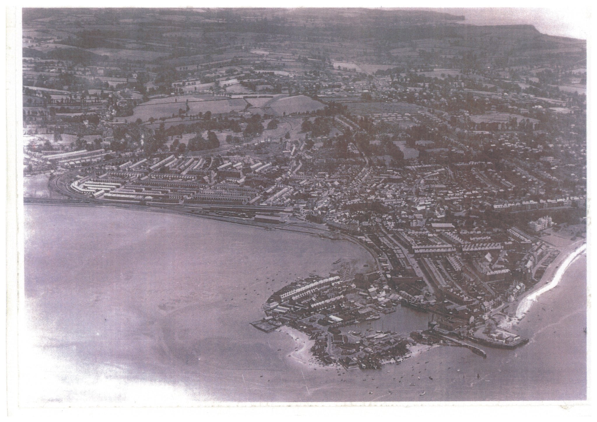
- Image 1a: Aerial view of the Exe Estuary Source: EEMP
The Exe Estuary in Devon, England encompasses over 3,000 hectares of diverse aquatic and terrestrial
habitats. It is designated as an Estuary of international importance for nature conservation.Protected from the open sea by the sand spits of Dawlish Warren and Pole Sands, the Estuary is naturally an ideal environment in which wild birds can feed and breed. These physical characteristics also make it a perfect open space for shellfish cultivation, tourism and a wide range of recreational activities. This report describes the Exe catchment area, investigates its value as a resource for Devon, and explores trends in diverse characteristics over time. The resulting collection of facts and figures contributes to our understanding of the condition of the Exe and will inform its future management.
Figure 1a shows the main settlements around the shores of the Exe Estuary.
Geology of the Exe Catchment
Figure 1b illustrates the different types of geology found within the Exe Estuary catchment. In the upper
catchment the geology is predominantly Devonian siltstones and sandstones (408 – 360 million years old). The carboniferous rocks (360-286 million years old) in the west of the catchment are typically mudstones altered to low grade shales. The end of the Triassic Period (195 million years ago) was marked by a marine incursion which flooded small areas of the south eastern part of Devon with a shallow sea in which a succession of limestone and shales were deposited. These deposits are known as the ‘Jurassic Beds’.The majority of soil types are well-drained, fine loams. Exmoor is characterised by low permeability peaty soils and the central catchment demonstrates loamy subsoils over clay subsoil, which are generally slowly permeable (Environment Agency, 2003). River erosion during the Quaternary Period (10 million years ago) gradually created much of the present day landscape of Devon. The rises in sea levels that occurred with the melting of great ice sheets caused many of Devon’s river valleys to be drowned by the sea, creating the estuaries of the Dart, Taw and Torridge, and the Exe (Devon County Council, 2004).
Geology and soil type are important determinants of erosion levels, sediment dynamics and siltation. The different geological environments provide the basis for a variety of habitats which support a wide range of species within the Exe catchment.
- 1.1 Land Ownership
The Exe Estuary has seven fundus1 owners: (i) The Crown Estate, (ii) Manor of Kenton (Powderham Estate), (iii) Lympstone Fishery & Harbour Association, (iv) East Devon District Council (EDCC), (v)Teignbridge District Council, (vi)Devon Wildlife Trust and (vii) Martin McGahey (as shown in Figure 1c).
The Crown Estate and EDDC have leased a substantial part of their fundus to voluntary bodies with commercial proposals, such as the Lower Exe Moorings Association (LEMA) and the Topsham Mooring Owners’ Association (TMOA), and with conservation proposals, such as Devon Wildlife Trust (Old Sludge and Exe Reed Beds reserves) and EDDC (Exmouth Local Nature Reserve). Devon Wildfowling and Conservation Association (DWCA) also has a lease agreement with the Crown Estate to practise wildfowling in some intertidal areas of the Estuary.
The fundus of the inner and outer part of Dawlish Warren National Nature Reserve is owned and managed by the Devon Wildlife Trust and Teignbridge District Council respectively, though the Manor of Kenton retains manorial rights over the land.
Figure 1c shows the freeholds on the fundus of the Exe Estuary.
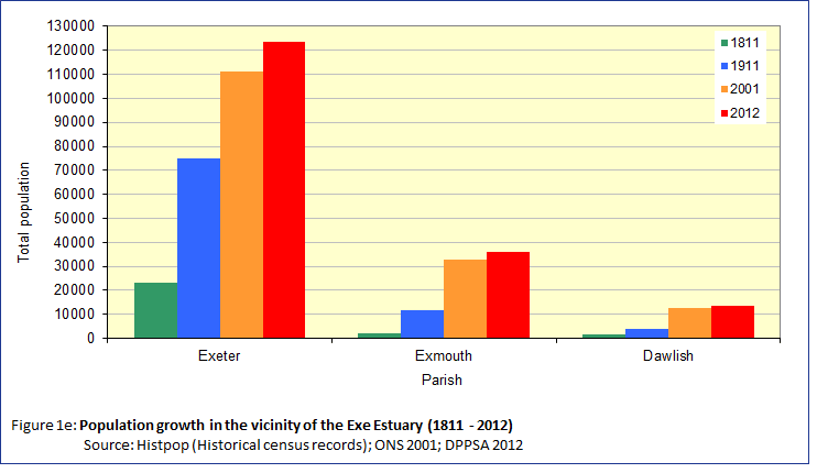
- 1.2 Population
The population of the Exe catchment area has increased considerably (Figure 1e). The consequent pressures on the natural and human resources are considerable and require careful management in order to avoid degrading the rich and diverse environment on which people rely.

- 1.3 Social and Economic Background
Human Settlement
Migration trends show an average increase in the number of people living in the areas surrounding the Exe Estuary, although as economic growth has slowed since 2008, so has in-migration.
When the population of Devon increases, the demand for property continues to grow and coastal and waterside properties are in high demand. In 2011, 43.1% of Devon’s population lived in coastal wards (Census, 2011). The average house price in the districts around the Exe Estuary have continued to rise.
New Housing Developments
Over the coming years, the number of people living close to the Exe Estuary will increase, as a result of housing allocations in the local planning documents of Exeter City, East Devon District and Teignbridge District Councils, and outstanding planning permissions and other developments.
New housing will increase the number of local residents and the consequences of this growth will affect different sectors, such as education, healthcare, local economy and natural environment.
The three local authorities around the Estuary have a legal duty to ensure no adverse effects occur to the Estuary as a result of their strategic plans and it is therefore necessary to address the anticipated impacts.
The local authorities of East Devon, Exeter, Mid Devon and Teignbridge and Devon County Council are working together, engaging with stakeholders and communities, to prepare a Greater Exeter Strategic Plan (GESP). This formal statutory document will provide the overall spatial strategy and level of housing and employment land to be provided up to 2040.
Index of Multiple Deprivation
The Index of Multiple Deprivation is a measure which combines data on deprivation in 7 ‘domains’; education, employment, income, health, crime, barriers to services and environment. Scores are ranked to show the relative degree of deprivation of all the Lower Super Output Areas (LSOAs) in England.
As a county, Devon has a level of deprivation which is much lower than the national average but there are some Devon LSOAs that feature in the top 20% nationally – most of these are either in Exeter or North Devon (Ilfracombe and Barnstaple) but there are isolated areas elsewhere. When looking at comparative deprivation within Devon, the areas bordering the Exe Estuary of relatively higher deprivation are in Exmouth, Dawlish and on the edge of Exeter. In contrast there is relative affluence in Exminster, Exton, Topsham and Lympstone.
Employment
Employment by sector in Devon and in the districts surrounding the Exe Estuary is dominated by work in the wholesale and retail sector, followed by health and financial services. The Met Office based in Exeter is also a major employer in the region.
- 1.4 Managing the Exe Estuary
Managing the Exe Estuary is an essential part of ensuring its sustainable development and use. Management is complex and involves balancing international and national legislation with local Byelaws and other competing priorities. With three local authorities bordering the Exe Estuary and a range of organisations responsible for different activities the need for a co-ordinating management body such as the Exe Estuary Management Partnership is essential to promote an efficient, integrated approach.
More information can be found on The role of the Exe Estuary Partnership and our Partners pages.

Chapter 2. Climate Change
- 2.1 The Climate and how it is changing
Long term changes in the climate as a result of the redistribution of the continents around the globe, and changes in the Earth’s orbit and the Sun’s output have shaped the landscape we know today. The Exe Estuary is a drowned river valley, or ria, inundated by a sea level rise of 120 metres that took place from the end of last Ice Age 18,000 years ago to about 4,000 B.C. Whilst we do not expect changes of that magnitude to take place in the coming century as a consequence of human-induced climate change caused by greenhouse gas emissions, some of the physical attributes of the Exe Estuary will change during our and our children’s lifetimes.
The evidence for climate change is irrefutable and the 2014 Fifth Assessment Report from the Intergovernmental Panel on Climate Change has concluded that it is very likely that human activities that emit greenhouse gases has been the main cause of the observed warming since the mid-20th century.
Climate Change Impacts
The 2006 Stern Review on the Economics of Climate Change, commissioned by HM Treasury concluded that, without intervention, the overall costs of climate change impacts will be equivalent to losing between 5% and 20% of global GDP each year, now and forever. Encouragingly, mitigating Greenhouse Gas emissions to avoid the worst impacts of climate change will cost only 1% of GDP each year by 2050.
Climate change will affect all sectors of society. Industry and commerce will be affected by changing demands for goods and services, as well as higher insurance costs and the financial implications of interruptions to logistics caused by the weather. Utilities, infrastructure and buildings will have to be designed to withstand new temperature, rainfall and UV light ranges. And the health sector will need to adapt to new health complaints and an increased incidence of heat related conditions.
There will be several impacts on the natural environment as well. Particularly in the Exe Estuary, the inter-tidal areas such as saltmarsh, sandbanks and mudflats, which are visible at low tide, will be under water for more of the time as the sea level rises. These important habitats will be prevented from moving further up the shore by the presence of man-made defences, such as sea walls. This process is known as “coastal squeeze”. The loss of these habitats, which are legally protected by both UK and European law, will affect resident and visiting wildlife including many internationally important wading birds. Current law requires that coastal squeeze is either avoided or compensated for by creating new areas of suitable replacement habitats.
More information about climate change in the Exe Estuary and how this compares with coastal areas across the channel in Normandy, France can be found in the Two Countries One Sea report.
- 2.2 Adapting to Coastal Change
The Exe Estuary coastline has evolved over thousands of years. Storm waves, high spring tides and gale force winds have battered our coast, resulting in erosion of cliffs and beaches, whilst on-going coastal processes like longshore drift and tidal currents move sand and sediments around on a major scale. Land reclamation, construction of flood defences, transport links, such as railway lines, and housing development have also all played their part in shaping the coastline that we know and love today.
To prepare for the likely effects of climate change a number of organisations undertake monitoring activities around the Exe Estuary in order to identify and assess the coastal process taking place on the Estuary and the vulnerability of sites and habitats. Engagement activities are also undertaken so that local people and organisations have an opportunity to have a say in how their coast is managed. Appropriate management measures have been developed to manage the risks of sea level rise and coastline erosion for people, properties and the environment. More details about the Flood and Coastal Risk Management of the Exe Estuary can be found in the section towards the bottom of this web page.
Living with a Changing Coast
The “Living with a Changing Coast” (LiCCo)
 project was a three-year cross-channel project completed in 2014 and part funded by the EU INTERREG programme. The project aimed to help coastal communities to better understand, prepare for and adapt to the impacts of climate change, sea level rise and erosion on the natural and human environment. Partner organisations included the Exe Estuary Management Partnership, Dorset County Council, the National Trust and a number of bodies in Normandy, with leadership provided by the Environment Agency. The project focussed on seven coastal study areas in England and Normandy, France, including the Exe Estuary.
A variety of activities were undertaken through the LiCCo project, including using history to tell the story of coastal change by gathering community memories and historic paintings, engaging with local communities and improving understanding on coastal issues and management, sharing learning and best practice between project partners and improving knowledge about coastal habitats, and plant and animal species that act as indicators of climate change
There are a variety of resources available on the LiCCo website, including award-winning school education packs.

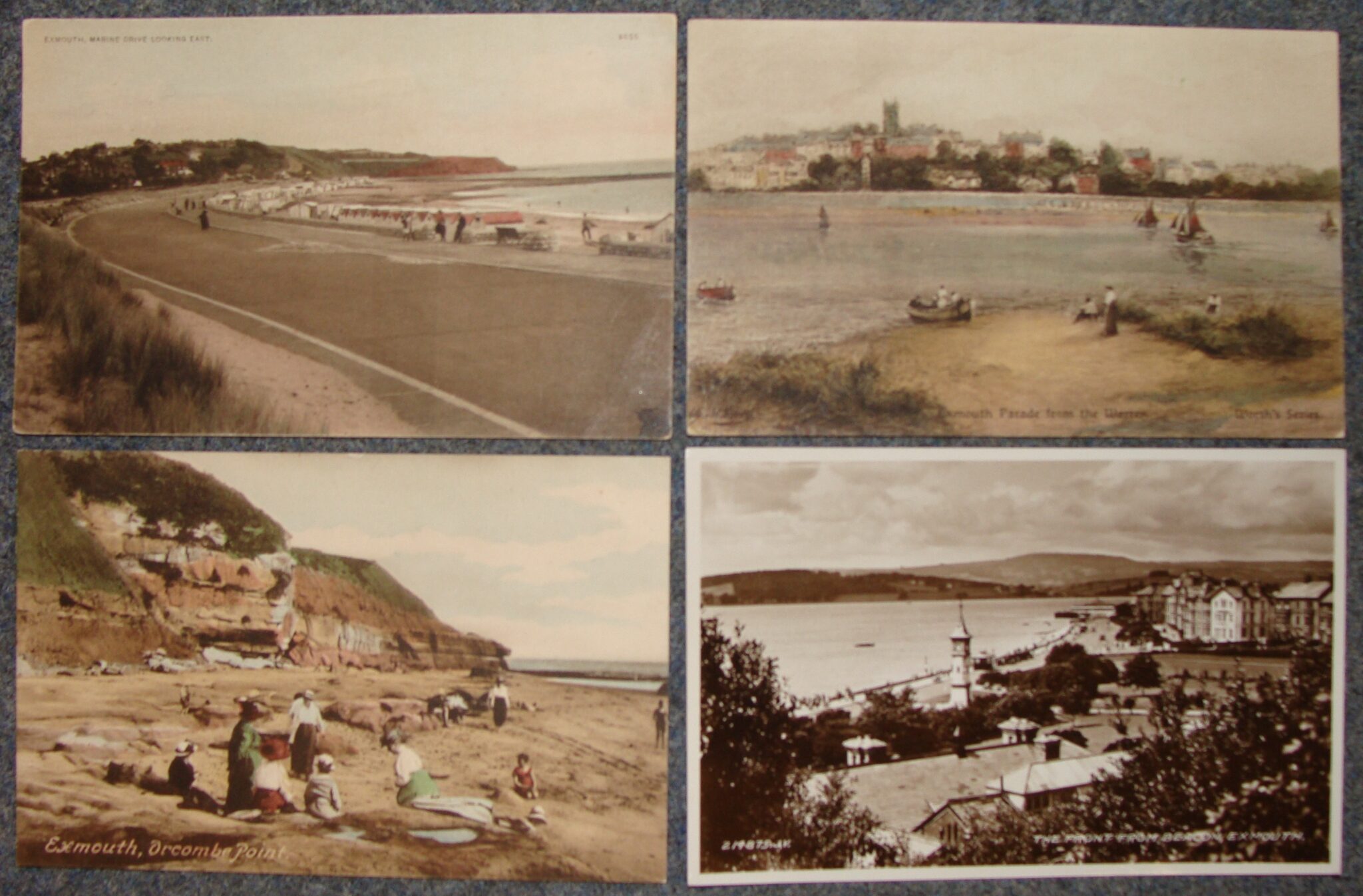
- Image 2e: Historical photos of Exmouth and Dawlish Warren
Source: EEMP
- 2.3 Carbon Emissions and Energy Use
Devon Climate Emergency
Following the declaration of the Devon Climate Emergency in 2019, the Devon Carbon Plan is being developed by the Net Zero Task Force (which includes environmental, economic, health and academic specialists). The plan is being created in consultation with local experts and the general public to ensure the Devon Carbon Plan is reflective of the opinions of the people of Devon.
The climate is already changing, and we all need to start preparing to live in a warmer world. The Climate Impacts Group will prepare a Devon Adaptation Plan highlighting the actions required to ensure community and environmental resilience. For Devon, one of the largest implications will be sea-level rise and how this will impact our natural environment, communities, businesses and infrastructure.
For example, coastal margin habitats, such as the inter-tidal areas of the Exe Estuary including saltmarshes and mudflats, are globally important in the fight against climate change because they can capture carbon and store it in their soils. The carbon storage potential of coastal habitats is now considered to play a significant role in the regulation of both local and global climate. When the marshland plants die, rather releasing their carbon into the atmosphere through decomposition, they become buried in the mud. As sea levels rise, more sediment covers the tidal marshes and buries this carbon-rich material, locking it beneath the muddy layers. This acts as an adaptation measure as this additional sediment enables wetlands to build elevation as the sea rises. But for wetlands to build up and store more carbon, they will need space.
There is a risk that these important habitats will be prevented from moving further up-shore by the presence of man-made infrastructure, such as sea walls. This process is known as “coastal squeeze”. These habitats will also be at risk from increased erosion and changing physical conditions (including temperature, salinity and sediment transport) due to climate change. To ensure these valuable habitats can survive in a warmer world with higher sea levels, we need to be thoughtful of the future use and development of the Estuary, ensuring there is enough space for these habitats to thrive so they can continue acting as an essential carbon store.
To help fight the climate crisis, everyone needs to be involved. We all need to reduce our emissions and contribute towards a net-zero Devon. Businesses and organisations who are committed to reducing their emissions can sign the declaration.
Check out the Devon Climate Emergency website and follow them on social media:
Renewable Energy within the Exe Estuary Partnership Management Boundary
The contribution of energy use to climate change is a driver in the development of renewable energy schemes. The potential for large scale renewable energy such as wind turbines does not exist on the Exe Estuary, but there may be scope for small scale, domestic or commercial generation of renewable energy. At present there are no significant examples of renewable energy generation being practiced on the Exe, but solar energy could be used to run more outdoor, public facilities such as parking meters. Using renewable sources to generate energy would not only reduce the environmental impact of daily life on the estuary, but could also bring financial savings and benefits for individuals or businesses pursuing renewable energy generation.
Chapter 3. Natural and Historic Environment
- 3.1 Wildlife, Habitats and Designations
Habitats
The Exe Estuary and its surrounding hinterland is an incredibly rich and diverse area encompassing many different habitat types. Among the important habitats on the Exe are mudflats and sandflats, mussel beds, eelgrass beds, sand dunes, salt marsh and intertidal reedbeds. More information on the Exe habitats can be found on our Habitats page.
These habitats are a mixture of intertidal and subtidal areas. Intertidal means that at high tide the habitat is covered by water, but at low tide it is exposed to the air. The greater part of the Exe Estuary comprises intertidal mudflat or sandflat, and are the main reason for the high nature conservation value of the Exe because they support large populations of invertebrates which attract internationally important numbers of wildfowl to feed at low tide. Subtidal habitats remain covered by the water of the estuary and are mostly soft or sandy sediments, although some areas of hard substrate are present in the middle reaches between Cockwood and Starcross. The maps below show the habitats of the intertidal and subtidal zones.
Figure 3a shows the intertidal habitats of the Exe Estuary.
Figure 3b shows the subtidal habitats of the Exe Estuary.
Eelgrass
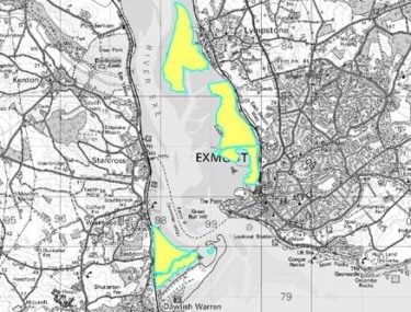
Eelgrass beds on the Exe Estuary have been monitored by the Environment Agency since 2008. Results show a significant increase in eelgrass coverage and distribution since surveying began.


Figure 3c – (left) shows eelgrass distribution in 2012 (right) shows distribution in 2019 highlighting the increase of eelgrass distribution in the Exe, including new establishment at Lympstone. Credit: Environment Agency
Marine Non-Native Species
Non-Native Species are those that have been transported outside their natural range by human activity. This may be the deliberate movement of a species, for example in aquaculture, but more frequently the accidental transport of species as ‘hitchhikers’ such as those attached to the hulls of vessels.
In 2021 the EEMP liaised with the Marine Biological Association, Devon Biodiversity Record Centre and Exmouth Mussels to collate existing data into a Non-native species log. From this log (18 known species), a Top ‘10’ Most Unwanted document was created, divided into ‘5 already here’ and ‘5 to look out for’.
How Can You Help?
Tackling Marine NNS is a tricky area due to ‘out of sight, out of mind’ and mitigation measure are typically more complex than terrestrial species. When it comes to Marine NNS, prevention is better than cure and the best way to do this is to raise awareness around good biosecurity practice: CHECK, CLEAN, DRY:
Check boats, equipment and clothing after leaving the water for mud, creatures or plant material. Remove anything you find and leave it at the site.
Clean everything thoroughly as soon as you can, paying attention to the inside of your boat, kayak or other equipment and areas that are damp and hard to access. Use hot water if you can.
Dry your kit. Drain water from every part of your boat or equipment and dry with a sponge or towel before leaving the site. Then dry everything for as long as possible before using elsewhere as some invasive plants and animals can survive out of water for two weeks on damp clothing and equipment.
It’s even more important to do this if you’re taking your kit abroad. Make sure everything is clean and dried before you use it again at home.
Designations
The different habitats of the Exe Estuary support a diverse and abundant range of flora and fauna, including wintering waterfowl and waders. Some areas of the Exe Estuary have multiple habitat designation, for example an area might be a Site of Special Scientific Interest (SSSI) and also a Ramsar Site. The habitat designations of the Exe Estuary can be found on the Wildlife Designations page. There are also several areas of the estuary that are especially important for nature conservation, which can be found on the Nature conservation sites page.
All competent authorities have a duty to protect and, where possible, enhance the SPA and the SSSI. Natural England is responsible for providing nature conservation advice to the regulating organisations; these organisations may include the Marine Management Organisation, the Local Authorities and the Devon and Severn Inshore Fisheries and Conservation Authority. In cases where a license or permit from another organisation is not required, Natural England is the consenting organisation for activities or development within the protected site.
Natural England is also responsible for enforcing laws that protect the wildlife and the natural environment. The primary legislation protecting wildlife and habitats in England in Wales is the Wildlife and Countryside Act 1981. For instance, the SSSIs in England and Wales are legally protected under Section 28 of the Act.
Section 28P (Offences) of the Wildlife and Countryside Act 1981 (as amended) states that a person who without reasonable excuse:
6(a) intentionally or recklessly destroys or damages any of the flora, fauna, or geological or physiographical features by reason of which land is of special interest, or intentionally or recklessly disturbs any of those fauna, and
(b) knew that what he destroyed, damaged or disturbed was within a site of special scientific interest, is guilty of an offence and is liable on summary conviction to a fine not exceeding £20,000 or on conviction on indictment to a fine.
And
6A (a) intentionally or recklessly destroys or damaged any of the flora, fauna. or geological or physiographical features by reason of which a site of special scientific interest is of special interest, or
(b) intentionally or recklessly disturbs any of those fauna, is guilty of an offence and is liable on summary conviction to a fine not exceeding level 4 on the standard scale.
The condition of the SSSIs, Special Areas of Conservation (SACs) and Special Protection Areas (SPAs) in England is assessed by Natural England as part of a six-year cycle. This is one of Natural England’s statutory duties. The condition assessment is an expert judgement on the condition of either a site feature or a particular site unit based upon the best information available at the time. This information can be biological, chemical or physical in nature.
It is important that Natural England monitors the condition of a designated site to better understand how existing management practices are contributing to site condition and provide advice and support to the relevant owners/occupiers and stakeholders if necessary.
The criteria which Natural England uses for its condition assessments are described in the Favourable Condition Tables (FCTs). The six condition categories are:
- Favourable condition
- Unfavourable recovering condition
- Unfavourable no-change condition
- Unfavourable declining condition
- Part destroyed condition
- Destroyed condition
The FCTs are site specific together with the Citation (i.e. reasons for designation) and a list of Operations Requiring Natural England Consent (ORNECs). These documents are available at the Natural England website.
Natural England’s “Conservation Advice” for the European Marine Site also sets out the conservation objectives of the designated features and provides a framework for the assessment of the site’s features and to inform the sustainable management of the marine protected area. Conservation Advice for the estuary can be found on the Natural England Designated Sites View for the Exe Estuary and Designated Sites View for Dawlish Warren.
The designations require Natural England to be consulted over any “plans or projects” within the SPA, as well as the Marine Management Organisation (MMO) as a marine licence may be required for any works below the mean high water springs mark involving a deposit or removal of a substance or object, for example dredging or general development construction. The competent authority will consider whether a proposal will have a significant effect on the SPA and therefore whether an initial assessment needs to be undertaken to determine the potential level of impact and whether a plan or project can proceed. Advice can be sought from Natural England or the MMO, with full details on UK protected sites available on the JNCC website.
- 3.2 Landscape
The “Exe Estuary and Farmlands” is one of 68 Devon Character Areas that have been defined within the Devon Landscape Character Assessment. The written profile for the Exe Estuary and Farmlands Devon Character Area contains a description of the area’s character, constituent landscape character types, distinctive characteristics, special qualities and features, as well as the current and future forces for change and their landscape implications. It contains a landscape strategy and guidelines that seek to conserve and enhance the area’s distinctive character. It is aimed at guiding and managing the forces for change acting upon Devon’s landscapes so that their special qualities, distinctive character and valued features are conserved and enhanced
This is a landscape of open skies characterised by the sound of seabirds, the masts of boats, and mud and dunes at Dawlish Warren. Views over the river are distinctive and the detail of the scene changes according to tide and season. The open expanse of intertidal mudflat when covered with water reflects the colour of the huge skies above. The whole scene is framed by rising landform on either side, which provides low level enclosure. The land rises gradually to the high ground of Woodbury Common to the east and Haldon to the west. This landscape is complex and diverse, combining ridge and valley systems with the open estuary landscape and red sandstone cliffs. The patchwork of fields and hedgerows, designed landscapes, woodlands and estuarine and coastal features creates a landscape of high scenic quality which forms an important part of the setting to Exeter, Exmouth and Dawlish. The underlying red soils, frequent vernacular buildings, estuarine and coastal views and hillside backdrops lend a strong sense of place. The shoreline railway and canal add distinctiveness and frequent small boats and moorings emphasise the maritime character.
The Landscape Character Assessments also describe variations in the generic ‘Landscape Character Types’ found in this area. These comprise lower rolling farmland and settled slopes, lowland plains, marine levels, estuaries, dunes and cliffs. The Exe Estuary and Farmlands also forms part of the ‘Devon Redlands’ National Character Area defined by Natural England. Figure 3k shows the landscape character types of the Exe Estuary and vicinity.
The Devon Landscape Policy Group is recognised as the body responsible for creating, updating and promoting Landscape Character Assessments relevant to planning and land management decisions in Devon. The DLPG has published Advice Notes relating to landscape policy and evidence, including about Devon’s Landscape Character Assessments and their use in neighbourhood planning. The DLPG Advice Notes can be found on the following website, along with wider information about Devon’s landscape and the Devon Character Area profiles:
Landscape Character Type profiles can be found in the respective Local Plan websites:
The Devon Redlands National Character Area profile can be viewed here:
The Devon-wide landscape character type profiles for East Devon and Teignbridge are being updated. This presents an opportunity for the Exe Estuary Management Partnership to engage with the process and influence the guidelines used in land management and planning decisions.
Figure 3l shows the Landscape Designations within the vicinity of the Exe Estuary.
- 3.3 History and Archaeology
The Exe Estuary contains many varied sites of archaeological and historical importance. In common with many other estuarine and coastal locations the Estuary of the River Exe has been used by people throughout time. Estuaries can act as barriers, boundaries, places of entry and exit, communication routes and as a source of mineral and food resources. Archaeological sites within such areas are often specialised in nature and may include fish weirs, boat-building yards, quays and mills.
Early Settlements
In the case of maritime and intertidal zones such as the Exe Estuary, it is important to remember that the present coastline is comparatively modern. As recently as 6000BC the coastline would have been very much further seaward than it is now. Thus many former dry land sites are now in a submerged or intertidal environment.
Exeter Quay
Recent excavations here have revealed a sequence of quay facilities from the Tudor period onwards. At the back of it are a 17th century transit shed for the woollen trade (now the Quay House visitor centre), the imposing late 17th century Custom House with its fine decorated plaster ceilings, and an imposing set of stone warehouses from the 1830s.
Exeter Canal
The Canal and its associated basin and warehouses, weir, locks, quays and limekilns offers an insight into the economy and industrial archaeology of the Estuary from the Tudor period to the present day, and links Exeter Quay with the Estuary. Known as the earliest ship canal in England, it was built in the 1560s to take lighters, transporting goods to and from seagoing ships moored in the Estuary, to the Quay.
Powderham Castle and Park
Built by the Courtenay family, the Earls of Devon, Powderham Castle dates from the 14th century and consists of a later fortified manor house with associated formal gardens and deer park. The site is open to the public and medieval jousting events are staged in the summer.
Topsham
Topsham was clearly an important landing point on the river, below the city, throughout the Roman period. Recently an early Roman fort has been identified under the new school in Topsham, which was probably linked to the fortress at Exeter by a road on the line of the present Topsham Road. This appears to confirm Topsham’s Roman origins.
Brunel’s Atmospheric Railway
The Atmospheric Railway along the western bank of the Estuary opened in 1846 and was converted to conventional steam after 1848. A number of features of the original railway survive beside the course of the present railway, principally the engine house at Starcross.
Exmouth Branch Railway
After several route proposals, a branch railway down the east bank of the Exe Estuary, connecting the City of Exeter and the port town of Exmouth, was opened in 1861. Built in only 12 months, the branch line was exceptionally successful and 2,000 passengers each day of its first week.
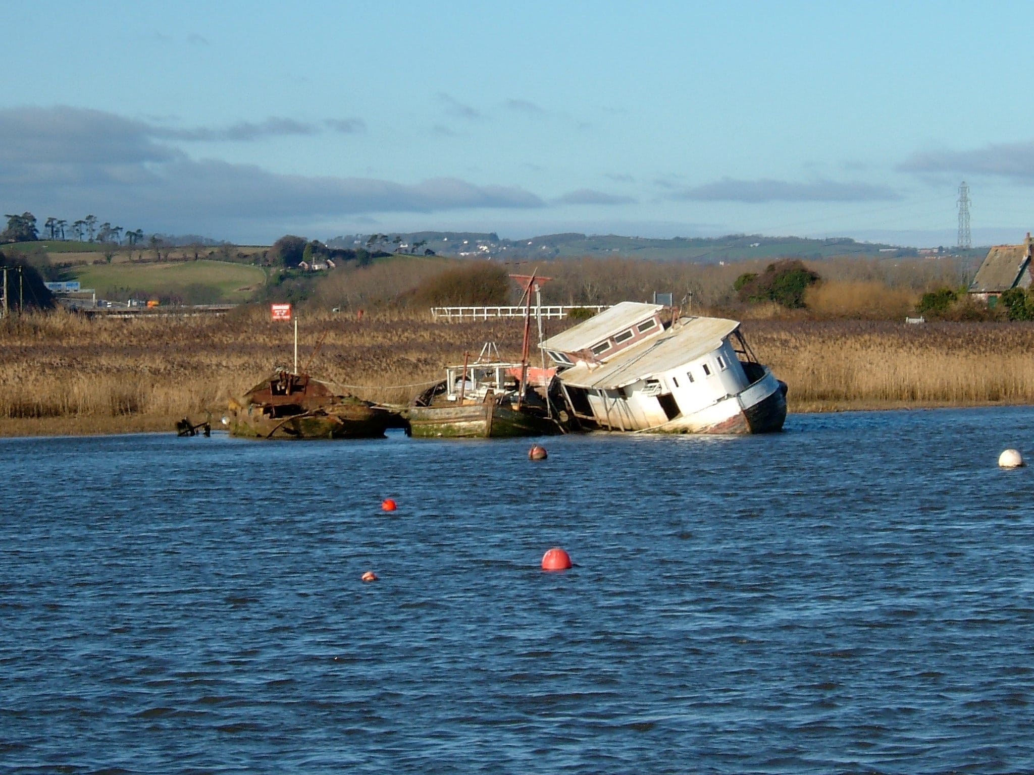
Historic Hulks on the Exe Estuary
The Exe Estuary contains a significant collection of abandoned vessels in relation to other estuaries in the South West, and is home to the largest known concentration of the remains of Brixham trawlers.

Chapter 4. Use of the Exe Estuary
- 4.1 Farming
Farming is an integral part of our landscape. It has the potential to enhance wildlife and biodiversity, and provide us with food, employment, export revenues and even improved water quality and flood protection. It is vital that the farming industry is supported to overcome economical and environmental pressures to ensure its ongoing function within society.
The area covered by the Exe Estuary Management Plan boundary is mainly characterised by mixed farming including:
Grazing for beef production: The majority of the farmland within the Exe Estuary Partnership’s management boundary is grazed for beef production. This mainly occurs on the low-lying areas where damp soils and the likelihood of flooding restricts the production of arable crops, e.g. the lowest parts of the Clyst Valley and most of the Exminster and Powderham marshes.
Grassland management for dairy production: This represents a small fraction (12%) of the farming activity and is mainly concentrated in the Clyst Valley.
Arable farming: Makes up the remainder, mainly around the margins of the Clyst Valley, along the Kenn Valley, and on the drier land behind Starcross and Dawlish Warren.
The Exe Agricultural Catchment
Information on farming can be collected in agricultural census¹ reports within sub-catchments of the wider River Exe catchment. The agricultural catchments associated with the Exe Estuary management boundary are the Clyst, Exe Tidal and Exe Lower.
In 2005 the census shows that there were 685 holdings in the Clyst, Exe Tidal and Exe Lower areas, most of which were located within the Exe tidal area. In 2010 the total number of agricultural holdings was 540 and the decrease is due a change in the way DEFRA collects the data. From 2010 onwards the data is only collected from commercial holdings (with a significant amount of farming activity). In Devon around 45% of holdings are regarded as non-commercial farming, therefore they have been excluded from the recent DEFRA June Survey of Agriculture². In addition, in 2009 DEFRA conducted a register cleaning exercise to remove inactive holdings from the database. Figure 4b shows how the types of agriculture found around the Exe Estuary and the number of farms has changed between 2005 and 2010.
Figure 4c shows how farm sizes have changed between 2005 and 2010 and Figure 4d shows how numbers employed in agriculture have changed over the same time. The 2010 census shows small differences in the number of full time and part time farmers within the sub-catchments. Compared with the 2005 data the number of full-time farmers has declined, likely explained by farmers either semi-retiring from agriculture or reducing their level of farming activity as a strategy to increase off-farm work. The farms in the Exe Tidal catchment are predominantly livestock (sheep) and woodland, whilst the Clyst catchment supports more cereal and dairy farming, as shown in Figure 4b.
The next census will take place in 2021.
1 Results are from the June Survey of Agriculture 2005 and 2010, a large sample surveys sent to representative samples of holdings across England. As the results are based on sample surveys, they are subject to a degree of sampling error and do not take into account other sources of survey errors, such as non-response bias or administrative data errors.
2 Dr. Matt Lobley, CRPR, Exeter University (personal communication)
- 4.2 Fisheries
Fish and shellfish are an essential part of the estuary environment. Healthy stocks are an indicator of good environmental quality and the fishing industry is a historically and culturally important aspect of the Exe, providing locally caught fresh seafood. With increasing pressure on the inshore fisheries industry, careful monitoring is essential in order to maintain stocks for future generations.
Fish species of commercial interest on the Exe include salmon, sea bass and sand eels. There are also some small scale recreational or low scale commercial gathering of shellfish which include cockles, clams, winkles and oysters as well as crab. Digging for lugworm and rag worm for bait is fairly common on the Exe.

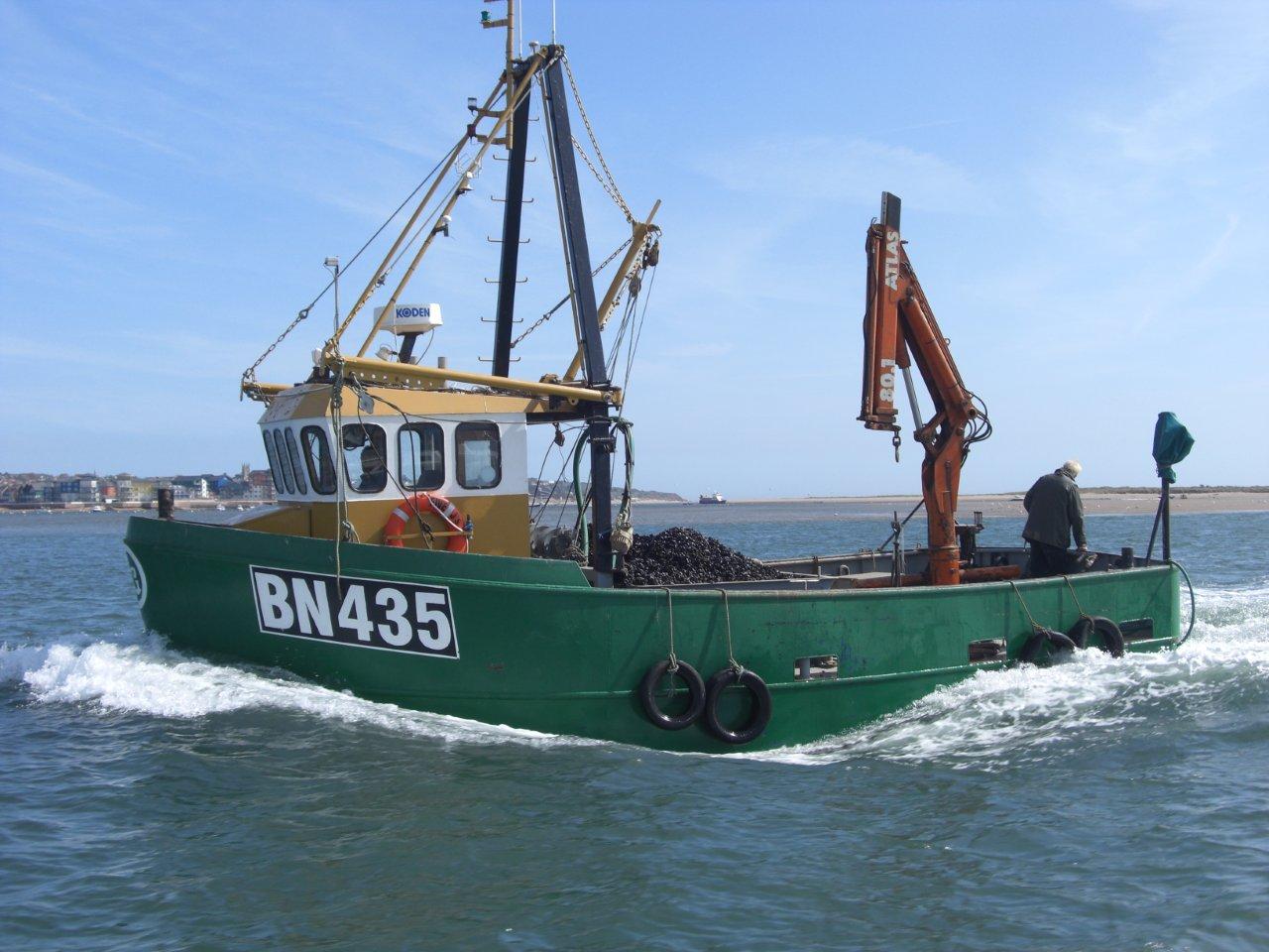
- Mussel boat on the Exe Estuary
Credit: Devon Maritime Forum
Mussels are harvested commercially by the Exmouth Mussel Company , which gathers seed mussels from the sand banks within and outside the Exe Estuary and moves them to more sheltered areas within the estuary (including a private
area of foreshore and fundus owned by the Earl of Devon), where they are left to grow to market size before harvesting. These activities are subject to Habitats Regulations Assessment. The areas marked in Figure 4f are classified as bivalve mollusc production areas under the Food Safety Regulations 1998 and the responsible food authorities are Teignbridge District Council and East Devon District Council. There are other mussel beds in the Exe including the beds at Lympstone and Bull Hill Bank, which are not classified for commercial harvesting and provide an invaluable food source for bird populations. These wild mussel stocks have declined over the past few years, in a similar manner to other South Devon estuaries.
Statistical data on fish landings at Exmouth can be found on the Marine Management Organisation (MMO) website . It is important to note that some of the fish species landed at Exmouth, such as whelks and lemon sole are not caught within the Exe Estuary.
Management of Fisheries
The Secretary of State for Environment, Food and Rural Affairs is responsible for setting policy on salmon and freshwater fisheries in England. Within this policy framework, the day to day management and regulatory responsibility for salmon and freshwater fisheries (including trout and eel) rests with the Environment Agency, who have powers to make Byelaws and Net Limitation Orders.
The sea fisheries on the Exe are managed by Devon and Severn Inshore Fisheries and Conservation Authority (D&SIFCA), which is responsible for managing the stocks and following UK and EU legislation to ensure that fishing activity within the Exe Estuary Special Protection Area (SPA) does not negatively impact the designated features of the site.
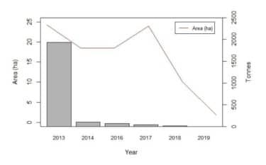
The latest D&S IFCA survey and report on mussel stocks was undertaken in 2019 and revealed a continued decline in mussels on the Estuary following the 2014 storms. This led to the temporary closure of the Bull Hill mussel bed in May 2019 (which continues to be closed).

Figure 4g: Total survey area found to contain live mussels plotted over total stock 2012-2019. Credit: D&S IFCA
D&S IFCA also survey cockles on the Exe Estuary and produced the 2010-2018 cockle report showing their findings. The report is due to be renewed and will be published in 2021.
On the Exe, D&SIFCA byelaws have been put in place to manage fishing activity which includes mussel harvesting, shore crab harvesting, a minimum size for winkles, dredging and netting. D&SIFCA are currently undertaking a review of all their Byelaws, which may allow for the management of fishing activities through a permit system in the future. D&SIFCA have an enforcement role and make regular patrols and inspections of fishing vessels and equipment. They also advise fishermen and shellfish farmers on appropriate techniques. D&SIFCA Officers carry out shore visits and boat patrols of the Exe Estuary.
More information about fisheries on the Exe Estuary can be found on our Commercial activities page.
We have received increased reports of suspicious activity taking place on the Exe and potentially illegal, commercial scale hand gathering of shellfish. Please report any suspicious activity to Devon & Severn IFCA on the following number: 07740 175479
Rod Fishing Byelaws
These regional byelaws apply to all waters in England to protect fish stocks, whether they are owned by angling clubs, local councils or private individuals. Owners may impose additional rules, but the byelaws must still apply to their water. The Environment Agency is the body responsible for rod fishing byelaws. Anyone fishing with a rod and line must hold an Environment Agency rod fishing licence and comply with the byelaws that cover the waters where they are fishing.
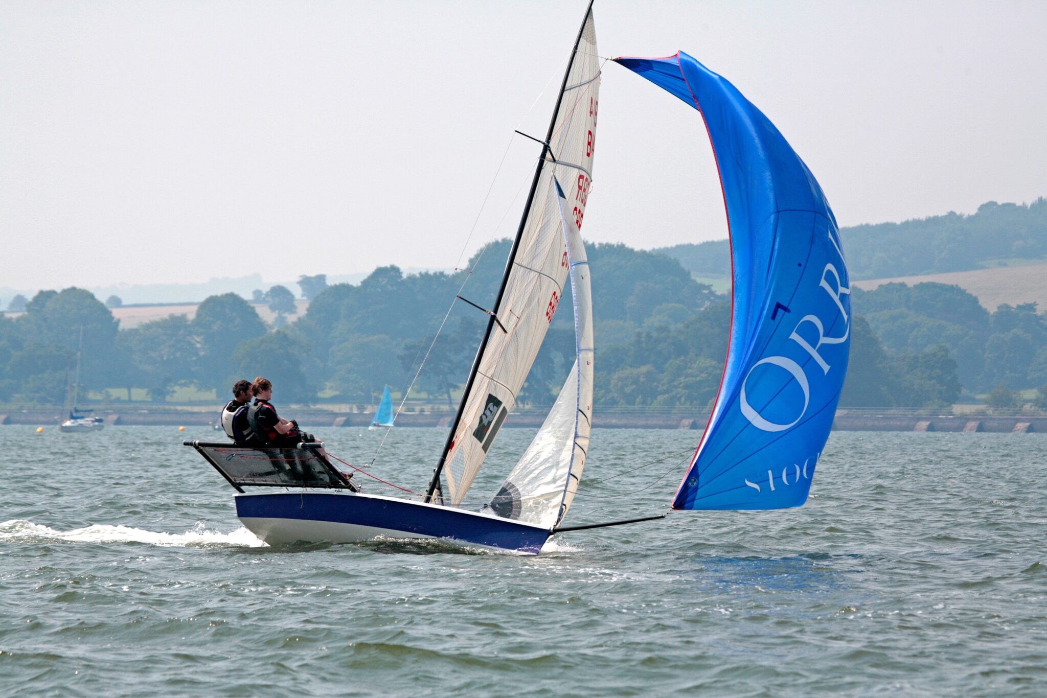
- 4.3 Water Based Recreation

Water based recreational activities are becoming more and more popular on the Exe Estuary providing an excellent way for the public to enjoy open spaces, to appreciate the environment, and to engage in a healthy lifestyle. Watersports enjoyed on the Exe include sailing, boating, windsurfing, kitesurfing, water-skiing, wakeboarding, paddle boarding, jet skiing (personal water craft), canoeing and kayaking. More information about these activities can be found on our Water based activities page or in our Exe Activities leaflet. The Exe Estuary provides space for about 1,900 moorings (including pontoon berths at the marinas and harbour, details of which are in the Marine Leisure section) and follows a mainly seasonal pattern of activity concentrated between the end of March and the beginning of October.
Use of the water space is naturally zoned to an extent by restrictions of shallowness, the large tidal area, and a limited number of access points. However, with population growth and more people wanting to use the estuary for recreation, competition for space on the water is intensifying and conflicts between user groups can arise. It is important to ensure all users of the Estuary are given adequate space to enjoy their recreational activity without threatening or causing undue damage to the wildlife, the estuary’s conservation status, or other users.
Several of the local authorities around the Estuary – notably Exeter City Council – have created byelaws intended to safely manage the various activities, enforced through the presence of the Harbour Authority’s Patrol Boat. Byelaws, including those which set out areas for activities on the Exe, are illustrated in Figure 4h. In 2014, the Exe Estuary Partnership created the Recreational Framework document which compiled information about the current activities on and alongside the Exe, together with a review of the existing behavioural controls that manage these activities, to help inform management of the site. Various Exe Codes of Conduct were developed in 2018 through the Exe Estuary Management Partnership to help encourage the safe enjoyment of the estuary for the benefit of both people and wildlife species.
The South East Devon Habitat Regulations Executive Committee (SEDHREC) has a role in mitigating the impacts arising from new development and population growth within 10km of internationally important conservation sites which include the Exe Estuary and Dawlish Warren. The Committee is a legally constituted partnership between Exeter, East Devon and Teignbridge Councils. Mitigation Officers that represent this partnership deliver a programme of public education for users of the Exe Estuary, and can either be found on foot or on the water in their patrol boat (a different vessel to the Harbour Authority’s).
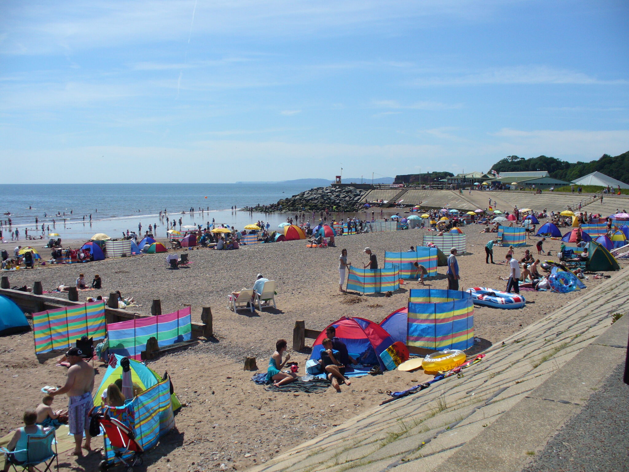
- 4.4 Tourism
- Dawlish Warren during the summer.
The Exe Estuary is a popular tourist destination, which provides a boost to the local economy, generating employment and ensuring local facilities are maintained. It is important to ensure that tourism is managed so that it does not negatively affect the quality of life of local residents.
The “Value of Tourism 2012 Devon” report from South West Tourism Alliance (SWTA) showed that most tourist spending in Devon occurs between May and September, with a significant peak in July and August. January and February are the months with the least spend. Although many tourists want to visit a beach destination during the summer, the Exe Estuary offers an alternative winter attraction with the presence of thousands of wintering waterfowl which attract birdwatchers. In addition, although watersport activities peak in the summer, their popularity during winter is growing.
Tourism on the Exe
A further piece of relevant tourism research is the on-site Visitor Survey of the Exe Estuary undertaken by Footprint Ecology and Teignbridge District Council (Liley & Cruickshanks 2010). This work involved interviews with visitors to the Exe Estuary during the late winter period of 2010. The work highlights the high numbers of visitors to the estuary, even in the winter. It describes visitor access patterns, the routes undertaken during their visit and also shows where the people who visit the Exe travel from. The summary of findings is below:
- Total of 586 interviews were conducted.
- Much of the winter recreational use of the estuary is undertaken by local residents.
- Most interviewees were from East Devon, followed by Teignbridge District and Exeter.
- Dawlish Warren was the busiest site and Powderham the quietest.
- Apart from in Topsham, mid-morning was the busiest time period for groups entering all surveyed sites.
- Two thirds of visitors travel to the Exe Estuary by car. The next most common form of transport is walking.
- The majority of interviewees stated that they visited the estuary all year round.
- Dog walking was the main reason for visiting, followed by walking.
- 4.5 Public Transport, Access and Land Based Recreation

The Exe Estuary is served by a wide range of public transport including trains, buses and ferries. More information about the modes of transport available around the estuary can be found in our Exe Explorer leaflet.
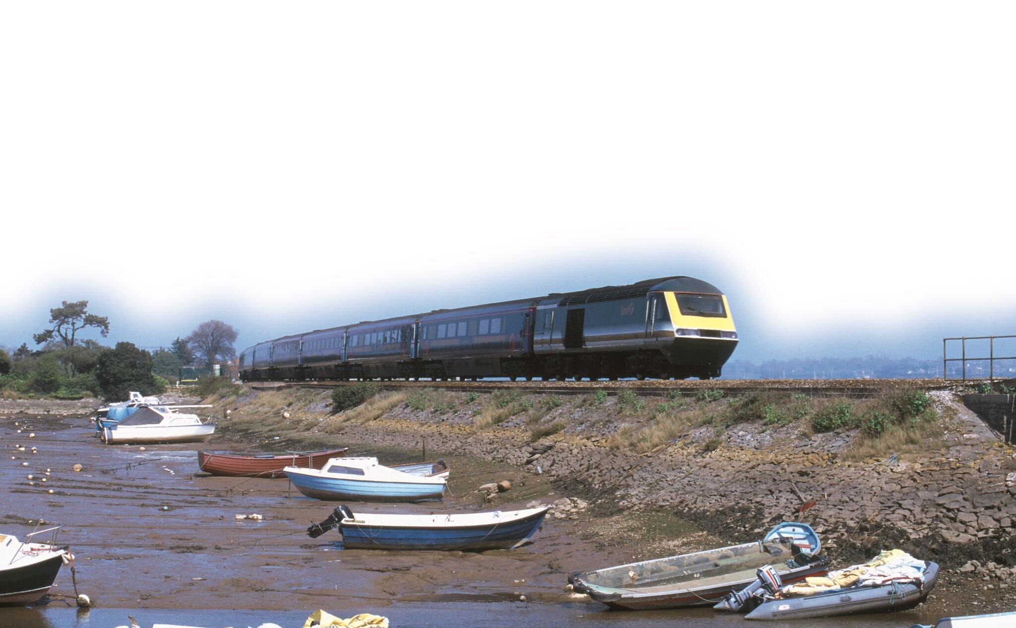
Trains
The Exe Estuary is well served by rail, with lines along both the western and eastern sides of the Estuary. The local network of train services is operated by First Great Western which connects Exmouth with Torbay and Barnstaple via Exeter. The line between Exmouth and Exeter is called the Avocet Line, and it calls at stations which provide good access to the estuary as well as opportunities to undertake journeys in combination with ferries and walking or cycling.
First Great Western also operate long distance services between London Paddington and Plymouth / Cornwall, which call at Exeter and make occasional calls at stations along the west of the estuary. Cross Country also operates long distance services from Exeter with occasional calls at Dawlish.
Buses
The principal bus services around the estuary are operated by Stagecoach South West.
They provide useful links between the residential areas around the estuary and the major employment sites in Exeter.
Ferries
Ferries run across and around the Estuary, particularly between Exmouth and Starcross; Topsham and Turf Locks; and Topsham and the Exeter Canal on the opposite bank. A water taxi operates from Exmouth Marina as a regular service for people and equipment to private craft moored on the river, but also occasionally transports people to Dawlish Warren. The Exmouth to Starcross ferry is the earliest documented ferry crossing in Devon. More information can be found on our Ferries and cruises page.
Exe Estuary Trail
Following a public consultation through Devon County Council, there was clear support for the provision of a shared cycleway and walkway around the Exe Estuary. An appropriate assessment was commissioned to ensure there was no adverse impact upon the integrity of the Special Protected Area / Ramsar site. The Exe Estuary National Cycle Network Route 2, known as the Exe Estuary Trail, provides a 26-mile cycling and walking route, connecting more than 80,000 residents to the beautiful riverside towns and villages steeped in maritime history. The trail is also part of the Tour de Manche cycle route that links Devon and Dorset to France. Interpretation panels have been placed along the Exe Estuary Trail to raise awareness and understanding of the Exe Estuary’s environment and heritage, and to influence visitor behaviour at sensitive sites.
There are also a variety of long-distance routes which can be found on our Exploring the Exe page.
Various land based activities are available around the Exe Estuary, which can be found on our web page here.
- 4.6 Navigation, Commercial and Other Uses
Due to its conservation designation, significant industrial activity is not allowed in the immediate vicinity of the Exe Estuary. The only real commercial uses currently found on the Exe Estuary are low impact marine business and commercial transport (shipping and rail transport). Since 1939, the Exe Estuary has also accommodated military activity, in the form of the Lympstone Commando Training Centre.
The History of Exmouth as a Commercial Dock
Exmouth Docks were built in 1865. Prior to this, lighters were used to unload cargo from ships moored offshore. Once built, the number of steamers using the docks rose steeply from eight in 1889 to twenty-five in 1890, and it was expected that two thousand would dock by the end of 1891. This development necessitated the employment of dock workers from the surrounding area to handle the numerous goods that arrived by steamer, including barley, wheat, maize, peas, potatoes, currents, hides, fertiliser, railway iron sleepers and stones. In the 1890s steam tugs came into service with the steamship taking priority over the vessels whose arrival was weather dependent. The docks were also being used for fishing boats at this time.
By 1934, 150 large ships entered the Docks and facilities were improved to meet its growth. A railway served several of the berths within the Docks and connected with the main station. Coal was now the main imported good received by crane into the Docks. Timber was also brought in from Scandinavia and Russia; and tanks of cider were pumped directly into rail tankers to be sent to retailers. However, the use of railway services ceased in 1967 when the Exmouth Station branch lines were closed and the dock splay system was dismantled. As coal plants were dismantled, grain became the main imported cargo and a large warehouse was built to accommodate bulk carriers of barley meal, maize, dried milk and fertilizer.
Questions about the Docks’ viability began to be asked in the 1980s and by December 1989 the Dock Company had decided that the handling of cargo ships should come to an end. The pier was then only used by fishing vessels, the Starcross Ferry and the RLNI tender. The Docks remained open for public use and became an attractive harbour for the use of visitors and locals (Saunders, 2000). In the 21st century the area has become a site for recreational users and the fisheries industry and has seen major redevelopment around Exmouth Marina with the development of many blocks of luxury apartments and associated facilities.

Harbour Authority – Patrol Boat
Exeter City Council has responsibility as the Harbour Authority for the Exe Estuary, as well as managing Exeter’s waterways including the canal and maintaining the navigation channel.
Use of the Exe Estuary for water based recreation increased dramatically over the years, and as a result a Harbour Patrol Boat was introduced to issue advice, educate water users, enforce speed regulations and generally promote safety on the estuary. In the 1980s a crew of two people ran the patrol boat on a full-time basis throughout the summer.
It became increasingly difficult for Exeter City Council to find crew and funding to maintain the operation of the Harbour Patrol through the 1990s and had to cease operation in 2000. Various initiatives through the Exe Estuary Management Partnership in conjunction with Exmouth police, Exmouth Town Council, volunteers and through donations from local organisations and clubs allowed the patrol boat to be reinstated through the busy summer periods.
In 2019, Exeter City Council employed a new Harbour Master and Patrol Officers who now operate the patrol boat. The Harbour Patrol have an important role to address antisocial behaviour on the water, educating users and enforcing byelaws to increase safety and protect wildlife from disturbance.
Rail Freight
The Great Western main line along the western bank of the Exe Estuary currently sees regular flows of timber and fuel, as well as occasional china clay traffic.
Military Use
The Lympstone Commando Training Centre was built in 1939 for the training of reservists. Initially, it was called the Royal Marines Reserve Depot and by January 1940 the first of many thousands of Royal Marines arrived at the Depot for training. In 1970 the camp was renamed the Commando Training Centre Royal Marines (CTCRM). Throughout the 1970s work continued to shape Lympstone into a centre of military excellence with a swimming pool and gymnasium complex and even its own railway station.
The Centre runs three training wings which cover recruit training, officer training, infantry support training, command courses for Non-commissioned officers and specialist training. An important aspect of Lympstone CTC is the Adventure Training Centre based at Exmouth Docks where regular courses in power boating and VHF radio courses are run. On average, 1,200 recruits, 2,000 potential recruits, and 400 potential officers attend training courses and acquaint courses at CTCRM every year. In addition, the Training Wings run upwards of 320 courses a year for a further 2,000 students.
Chapter 5. Environmental Quality
- 5. Environmental Quality
Improvements in the environmental quality of the Exe Estuary will lead to improvements in the quality of life for the local human and wildlife populations. In order to gain maximum benefit from the Exe Estuary environmental quality must be maintained or improved, which is particularly challenging in the face of increased pressures from a larger population and the greater variety of activities taking place on or around the Estuary.

- Image 5a The mouth of the Estuary. Source: EEMP
The 25 Year Environment Plan (2019) sets goals for improving the environment, within a generation, and leaving it in a better state than we found it. It details how the government will work with communities and businesses to do this and sets out what they will be doing over the next 25 years.
The Environment Bill aims to deliver the government’s manifesto commitment to delivering the most ambitious environmental programme of any country, to provide a step-change in environmental protection and recovery. It is one of the key ways of delivering the vision set out in the 25 Year Environment Plan.
The UK National Ecosystem Assessment provided the first analysis of the UK’s natural environment in terms of the benefits it provides to society and our continuing economic prosperity. An ecosystems approach provides a framework for looking at whole ecosystems in decision making, and for valuing the ecosystem services they provide, to ensure that society can maintain a healthy and resilient natural environment now and for future generations.
A strategic approach to managing England’s Natura 2000 sites, developed by Natural England, the Environment Agency and other key partners ‘The Improvement Programme for England’s Natura 2000 Sites (IPENS)’, has a Site Improvement Plan (SIP) for each Natura 2000 site (marine and terrestrial) in England. The plans provide a high-level overview of the issues affecting the condition of the site and identify the priority actions and mechanisms required to tackle those issues and the funding sources available. There is a shared SIP for the Exe Estuary Special Protected Area (SPA) and Dawlish Warren Special Area of Conservation (SAC) and this was developed in collaboration with the organisation(s) managing both sites and which have a role in delivering the actions required to improve their condition.
- 5.1 Air Quality
Air quality management is necessary to bring down air pollution to levels that are safe for people to breathe and to prevent air quality from worsening in areas where it is currently acceptable. There is some uncertainty over the health effects of air pollution and, although it is believed that the risks to individuals are relatively small, there is increasing medical evidence that air pollution damages health and can trigger asthma and other breathing illnesses. Pollution from traffic can cause lung damage and is associated with a number of breathing illnesses, such as bronchitis and cancers. In addition, air pollution has negative impacts on our environment, both in terms of direct effects of pollutants on vegetation, and indirectly through effects on the acid and nutrient status of soils and waters.
The National Clean Air Strategy (2019) sets out our plans for dealing with all sources of air pollution, making our air healthier to breathe, protecting nature and boosting the economy. This strategy sets out the comprehensive actions required across all parts of government and society to improve air quality.
Local Air Quality
The main pollutants affecting human health and wildlife around the Estuary are:
Nitrogen dioxide (NO2) is a toxic pollutant. Its main source locally is road traffic, but it is also emitted from marine diesel engines on the Estuary. This gas can irritate the airways of the lungs, increasing the symptoms of those suffering from lung diseases. Nitrogen dioxide can also bring about acidification of water and add to the nitrogen loading in soil.
Particulates (PM10) are pollutant particles up to 10microns in size. They can have an impact on the respiratory system and can carry carcinogenic compounds. In high levels, they could affect plant photosynthesis.
Ozone is a powerful oxidising agent which can affect the respiratory system and can be a threat for humans and wildlife. The chemicals that react in sunlight to produce this gas are capable of travelling long distances and could come from other parts of Europe. The main chemicals involved in this reaction are nitrogen dioxide and volatile organic compounds. The latter are released from, among other things, paints and varnishes labelled as “High VOC content” often used in boat maintenance. The concentration of ozone is greater on high ground and on still warm days, where there is very little air movement and intense sun.

- Image 5b Air pollution from boat emissions. Source: EEMP
Local Authorities and Air Pollution around the Exe Estuary
Part IV of the Environment Act 1995 introduced the concept of Local Air Quality Management. Local Authorities are required to review and assess Air Quality in their area against a range of standards and objectives. Where objectives are not likely to be achieved, then the local authority is required to designate an Air Quality Management Area (AQMA) – a geographic area defined by high levels of pollution and exceedances of National Air Quality Strategy objectives – and prepare an Action Plan to tackle the problems. There are no AQMAs within the management boundary of the Exe Estuary Management Partnership.
Although nitrogen dioxide and particulates levels are monitored by local authorities, the other important pollutant, ozone, is not currently monitored.
The quality of the air around the Exe Estuary is relatively good compared to more urban locations nearby. There are no significant industrial processes along the Estuary. The Marsh Barton Trading Area is the only potential source of industrial pollution other than unmonitored marine business and commercial transport, and therefore industrial air pollution is not really considered to be an issue for the Exe Estuary. Monitoring at the level of the Exe Estuary Management Partnership boundary is not seen as a priority, and data is often difficult to obtain. Data can usually be obtained at district level, which does not necessarily reflect the actual quality of air on the Exe Estuary.
The following is sources of information regarding air pollution management within the districts around the Exe Estuary:
- East Devon District Council Air Quality
- Teignbridge District Council Air Quality
- Teignbridge District Council Air Quality Action Plan
- Exeter City Council Air Quality Monitoring
- Exeter City Council Air Quality Action Plan
In Devon, a Net-Zero Task Force has been appointed, which will use its specialist knowledge and experience to produce an evidence-led Devon Carbon Plan. This will consider the earliest, credible, date that should be set for net-zero emissions. This, along with a national ambition to be net-zero by 2050, will result in the decarbonisation of motor-vehicles which is likely to bring about a progressive improvement in air quality. The use of older marine diesel engines could well mean that boating activity will then become the most polluting activity on the Estuary. However, because air does not stop at management frontiers, the Estuary’s air quality will also be affected by transboundary pollution caused by a multitude of other sources.
- 5.2 Water Quality
Water quality of the Exe Estuary is good, and to ensure that its remains so, international, national and local statutory requirements are in place and implemented around the Estuary.
Water quality is crucial to life in and around the Estuary. Poor water quality affects people and wildlife and has serious consequences for the local economy. If water quality were to be compromised, the sectors at the highest risk on the Estuary are the shellfish and tourism industry.

- Image 5c Exe Estuary Mussels. Source: EEMP.
Water Framework Directive
The Water Framework Directive (WFD) adopted in 2000 requires all inland and coastal waters to reach ‘good’ status. The waters in England have been broken down into water bodies for the purposes of River Basin Management Planning, thus recognising the importance of the entire catchment and how this may affect estuarine waters. The status and objectives for each waterbody, including the Exe Estuary, can be found in the South West River Basin Management Plan.
The WFD also specifies that areas requiring special protection under other EC Directives and waters used for the abstraction of drinking water are identified as Protected Areas. These areas have their own objectives and standards. Meeting their requirements will also help achieve Water Framework Directive objectives.
The types of protected areas are:
- Drinking Water Protected Areas – areas designated for the abstraction of water for human consumption;
- Freshwater Fish and Shellfish – areas designated for the protection of economically significant aquatic species;
- Bathing Waters – bodies of water designated as recreational waters;
- Nitrate Vulnerable Zones – nutrient-sensitive areas identified under the Nitrates Directive;
- Urban Wastewater Treatment Directive (UWWTD) – areas designated as sensitive;
Natura 2000 sites – areas designated for the protection of habitats or species (including Special Areas of Conservation and Special Protection Areas in the Exe Estuary). The maintenance or improvement of the status of water is an important factor in their protection.
Successful implementation of the WFD will help protect all elements of the water cycle and improve the quality of our groundwaters, rivers, lakes, estuaries and seas.
Economically Significant Species – Shellfish Waters
The Water Framework Directive also protects shellfish waters in order to support shellfish life and growth, therefore contributing to the high quality of shellfish products directly edible by people. The WFD sets physical, chemical and microbiological water quality requirements that designated shellfish waters must either comply with (‘mandatory’ standards) or endeavour to meet (‘guideline’ standards).
The Exe and Outer Exe Estuary are both designated Shellfish Waters. There are various classification of Shellfish Waters – the Shellfish Waters of the Exe have an all year round “B” Grade Classification, meaning that it is safe to eat the shellfish grown in its waters provided they have been relayed in a Classified “A” Area and depurated (purified).
Bathing Waters Directive
The EC Bathing Waters Directive outlines the legislation relating to the quality of bathing waters in England and Wales.
The overall objective of the Directive is the protection of public health whilst bathing. The bathing season continues to be between 15 May and 30 September every year and water is sampled weekly throughout the season and starts 2 weeks prior to the beginning of the season.
The Directive uses two microbiological parameters to assess water quality. In place of coliform and faecal Streptococci standards, the directive sets standards for Escherichia coli and intestinal enterococci.
Bathing water profiles can be accessed to help the public make more informed choices about the best locations to visit and enjoy. These include maps, potential sources of pollution, sampling points, photos and links to the latest water quality results.
There are four classes for bathing waters:
- Excellent
- Good
- Sufficient
- Poor
Bathing waters classified as poor will carry advice against bathing throughout the following season. If a bathing water remains classified as poor for 5 consecutive seasons the advice will become permanent.
Bathing Water Quality around the Exe Estuary
There are waters around the Exe Estuary designated under the Directive 76/160/EEC (Council of the European Communities, 1975), whose water quality is regularly monitored.
Using the Environment Agency “Bathing Water Data Explore” application, the profile for each designated Bathing Water in England and Wales can be accessed. Below are those within close proximity to the Estuary.
It is worth noting that the quality of the bathing waters may be adversely affected by several events, such as: rainwater running off roads, streets and farmland; operation of a sewer storms overflows; misconnection of domestic waste water pipes; and even dog faeces washed off from pavements and beaches.
River Quality within the Exe Catchment
Good water quality within the Exe Estuary can only be achieved if the water quality is also good upstream. The quality of river water within the whole catchment is an essential factor affecting people and wildlife, and monitoring is regularly carried out by the Environment Agency through the Water Framework Monitoring Programme.
The monitoring programme used to inform the River Basin Management Plans is based on a wider range of assessments and elements which are measured in each waterbody. For surface waters, good status is a statement of ‘overall status’ and has an ecological and a chemical component. Good ecological status is measured on the scale High, Good, Moderate, Poor and Bad. Chemical status is measured as Good or Fail. The classification is produced based on a ‘one out, all out’ principle. This uses the poorest individual element result to set the overall classification.
The Water Quality Archive provides data on water quality measurements. Samples are taken at sampling points around England and can be from coastal or estuarine waters, rivers, lakes, ponds, canals or groundwaters. They are taken for a number of purposes including compliance assessment against discharge permits, investigation of pollution incidents or environmental monitoring. The archive provides data on measurements and samples dating from 2000.
A Catchment Based Approach (CABA) is an inclusive, civil society-led initiative that works in partnership with Government, Local Authorities, Water Companies, businesses and more, to maximise the natural value of our environment. CaBA partnerships are actively working in all 100+ river catchments across England and cross-border with Wales, directly supporting achievement of many of the targets under the Government’s 25 Year Environment Plan.
The East Devon Catchment Partnership established in 2014 under the CABA programme, has the following objectives:
- To deliver positive and sustained outcomes for the water environment by promoting a better understanding of the environment at a local level; and
- To encourage local collaboration and more transparent decision-making when both planning and delivering activities to improve the water environment.
The Exe Catchment is comprised of 73 River waterbodies, 2 Lake waterbodies, 1 Transitional waterbody, 1 Coastal waterbody and 2 Canals. Significant water management issues in the River Exe Catchment include:
- Diffuse source pollution from mixed agricultural run-off
- Point source sewage discharges – Water Company, Industry
- Physical Modification – Flood, Urbanisation, Impoundment
- Physical Modification – Barriers to Fish Migration
- Diffuse source – Urban
The Environment Agency Catchment Data Explorer can be used to find out further information about the Exe Catchment
Nitrogen and Phosphorous Loading
High levels of nitrogen and phosphorous in a water course can cause excessive plant growth which has a number of negative effects in a water body, including the reduction of the oxygen content of the water – when the plant matter decomposes and can cause other organisms to die. This process is called ‘eutrophication’. Nitrate pollution is also a concern because it can make water unfit for drinking without additional pre-treatment and can damage the aquatic environment.
Phosphorous enters river and estuarine waters through soil erosion and sewage discharge, whilst nitrogen originates from fertiliser application, manure, and atmospheric deposition.
The Nitrates Directive (1991) forms an integral part of the Water Framework Directive. It is an environmental measure designed to reduce water pollution by nitrate from agricultural sources and to prevent such pollution occurring in the future. Under this Directive the River Exe (upper catchment) and the west side of the Exe Estuary, is classified as a ‘Nitrate Vulnerable Zone (NVZ) which means that it is an area of land known to be draining into nitrate polluted waters. Farms located within Nitrate Vulnerable Zones are required to adhere to an Action Programme of measures to reduce the amount of nitrate lost from their land to these waters.
- 5.3 The Sewage Issue
Sewage
While not the primary source of water pollution, sewage entering the estuary via Combined Sewer Overflows (CSOs) affects water quality and has been high on the agenda for various stakeholders who use the water for different purposes and are concerned about its state. Further information about water quality of the Exe Estuary can be found in the preceding section.
This is a summary of a report. To read more detail on each section please follow this link: Full report on Exe Sewage
On the Exe, Combined Sewer Overflows have been a topic of concern for various user groups and has been brought to the Exe Estuary Management Partnership (EEMP) as an issue to address. This has often been in the form of reported specific incidents of raw sewage entering the estuary. As such, it is important to understand that the EEMP does not hold a regulatory role and can only facilitate sharing information and holding regulatory bodies accountable.
Combined Sewer Overflows
Combined Sewer Overflows (CSOs) are part of sewerage infrastructure dating back to the Victorians. During heavy rainfall events capacity in our sewer system can be exceeded. Without CSOs in place this could result in potential back up flooding peoples’ homes, roads, and open spaces. CSOs work as an overflow valve to reduce the risk of this.
Environment Agency blog on CSOs
Government plans for sewage outflows
In September 2023, the UK Government expanded their previous Storm Overflows Discharge Reduction Plan document and published an updated version to include all coastal and estuarine sites. The targets set out in the new Plan will apply to every storm overflow in England, representing an increase from 91% to 100% coverage. The targets include requirements for water companies to:
- Improve 100% of storm overflows discharging into or near every designated bathing water; and improve 75% of overflows discharging to high priority sites by 2023.
- Improve all remaining storm overflows, regardless of location, by 2050.
Environment Act 2021
The government’s Storm Overflows Discharge Reduction Plan aligns with the Environment Act 2021, in which the government placed a legally binding duty on water companies to progressively reduce the adverse impacts of discharges from storm overflows.
South West Water
Waterfit Live South West Water’s Bathing water beach map
South West Water have installed Event Duration Monitoring (EDM) equipment on 100% of all their storm overflows. Publicly available data for the EDMs is available on the Catchment Based Approach Data Hub site.
Catchment Based Approach Data Hub

The map illustrates 100 CSOs located around the Exe estuary. The location data is from the Catchment Based Approach (CaBa) dataset Regulation
- The Environment Agency is responsible for issuing permits and regulating all discharges from storm overflows.
- Ofwat is the independent economic regulator for the water and sewerage companies in England and Wales.
Campaigning for better water quality
- West Country Rivers Trust is on a mission to improve water quality in rivers
- End Sewage Convoys and Poolltion Exmouth (ESCAPE) ESCAPE’S Facebook group
- Friends of the River Exe (FORE) Friends of the River Exe
- Surfers Against Sewage
Action you can take
If you spot a sewage outflow, this must be reported to the Environment Agency through their hotline 0800 807060. They will likely ask you a few questions including location and extent and notify South West Water, as well as The District Council.
You can also file a complaint to your local MP.
- 5.4 Waste Management and Recycling
The European Waste Framework Directive (2008) sets the basic concepts and definitions related to waste management. The Directive requires that waste be managed without endangering human health and harming the environment, and in particular without risk to water, air, soil, plants or animals, without causing a nuisance through noise or odours, and without adversely affecting the countryside or places of special interest.
The England Resource and Waste Strategy sets out how we will preserve material resources by minimising waste, promoting resource efficiency and moving towards a circular economy in England. This strategy aims to double resource productivity and eliminate avoidable waste of all kinds (including plastic waste) by 2050.
The Devon Waste Plan, adopted in 2014, establishes the overarching principles and policy direction for waste planning in Devon, it also identifies strategic sites for energy recovery across the County and a series of planning policies for making decisions on planning applications. The Plan covers the period to 2031.
Local Authority Waste and Recycling Statistics can be found here:
Local Authority Waste and Recycling Statistics
In recent years, Devon local authorities have worked hard to improve recycling opportunities for residents. Public awareness of the need to reduce, reuse and recycle waste is delivered through the award winning ‘Don’t Let Devon Go to Waste’ campaign from Recycle Devon. Educating children has also become an essential part of Devon’s long-term strategy to achieving a more sustainable future. Whilst the amount of waste recycled continues to increase and recent decreases in the total waste produced are welcomed, Devon authorities will continue to work with residents to reduce the amount of waste produced.
Waste Management and Recycling on the Exe Estuary
Local Authorities provide a number of recycling banks and recycling points in their area and this information can be found below:
- Exeter City Council Recycling Points
- East Devon District Council Recycling Points
- Teignbridge District Council Recycling Points
The provision and maintenance of these bins is the responsibility of the relevant district council.
Litter around the Exe Estuary
The presence of plastic and non-biodegradable materials on the shores of the Exe Estuary is an eyesore and can pose a danger to people and wildlife. Litter arrives on the shoreline from a variety of sources including down the river, from out to sea and from people using the beaches.
Since 2007 regular clean up events have been held around the Estuary, including at Exmouth, Dawlish Warren, Exton and Topsham. The Exe Estuary Management Partnership organises two Clean Up events for members of the public each year; a spring event at varying locations, such as Dawlish Warren Nature Reserve and a larger autumn event at Exmouth Local Nature Reserve. The events are very successful, often attracting over 100 volunteers and collecting more than two tonnes of rubbish, much of which is recycled.

- Image 5d: Beach Clean at Exmouth Local Nature Reserve. Source: EEMP.
Devon Wildfowling and Conservation Association also carry out regular litter picks of hard to reach areas of the Estuary and the Tidy Britain Group organises a beach clean at Dawlish Warren. Due to the increased awareness raised around plastic pollution from organisations such as Surfers Against Sewage and the Marine Conservation Society, beach cleans are also carried out by residents and other various smaller groups.
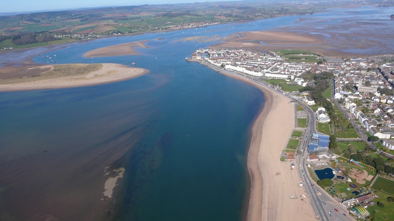
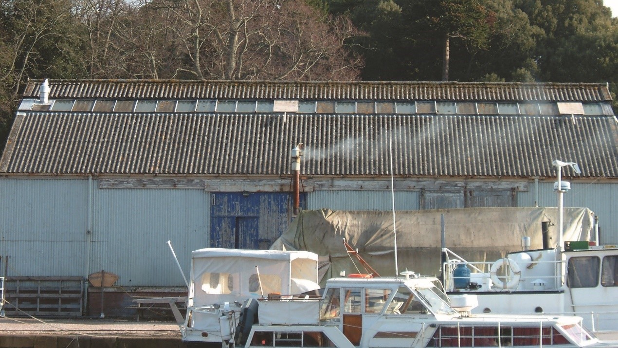
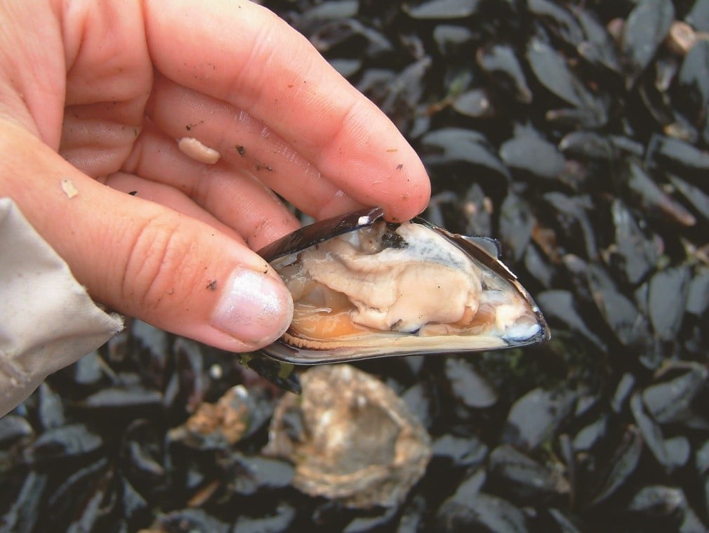
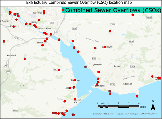
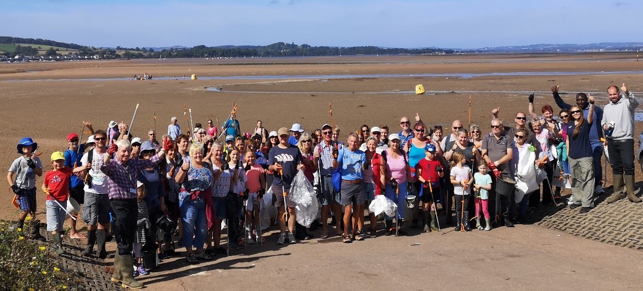
Chapter 6. Promoting Understanding of the Exe Estuary
- 6.1 Education and Interpretation
Providing education opportunities for the people who use the Exe Estuary is vital for the future sustainability of the area. It is important to promote a good understanding of the impressive ecosystems supported by the estuary in order to raise local awareness of their value. Providing easy public access to information encourages people to feel a sense of ownership for their natural surroundings and take an active interest in their management.
Education around the Exe Estuary

- Image 6a: Outdoor education session at Exmouth LNR. Source: East Devon District Council
The Exe Estuary Management Partnership offers hands-on educational sessions at Exmouth Local Nature Reserve, where children encounter some of the creatures that adapt to a changing estuary life, including shrimps, flatfish, worms and crabs. More information about these fun sessions can be found on our Education page.
The partnership works closely with East Devon District Council’s education rangers to offer even more opportunities for school children to explore the muddy estuary environment in Exmouth. The Countryside Team also manages the Maer Nature Reserve in Exmouth and offers an extensive programme of wildlife activities for all the family.
Teignbridge District Council manages a visitor centre on the Dawlish Warren National Nature Reserve which contains displays on local wildlife, habitats, geology and coastal management, for both children and adults and stocks a range of local publications. The Rangers here undertake practical conservation work on the site and offer a programme of public educational events.
The Royal Society for the Protection of Birds (RSPB) runs nature reserves at Exminster Marshes and Bowling Green Marsh, near Topsham. There are opportunities to volunteer here to undertake practical conservation tasks. Occasional public events are organised and school visits are sometimes possible. There are bird viewing hides at Bowling Green Marsh and also on private land at Darts Farm. The RSPB also organises popular Avocet cruises on the Estuary.
The Living with a Changing Coast (LiCCo) project is a cross channel partnership helping coastal communities to better understand and prepare for the impacts of climate change, coastal erosion and sea level rise. The Exe Estuary Partnership worked with various partners and a former Devon County schools geography advisor to develop Exe Estuary focused learning enquiries for primary and secondary schools, and A-Level students. All packs are supported by an extensive suite of resources, such as films, presentations, datasets, maps, paintings and historic photos and are designed to deliver multiple topics of the national curriculum. The packs are available free of charge to teachers, further details can be found on our Education page.
Based in Exmouth, Stuart Line Cruises offer award-winning Guided Bird Watching Cruises between the months of November to March, presenting the unique opportunity for people to discover the Exe Estuary’s prolific migratory bird life from the comfort of modern, covered and heated vessels. Whether you consider yourself a novice or an expert, leading local ornithologists guide passengers with an informative live commentary, detailing species, habitats and behaviours.
Interpretation Material around the Exe Estuary

- Image 6b: Interpretation board and Exe Trail marker on the Exe Estuary. Source: EEMP
The presence of interpretation boards and information signs around the Exe Estuary is another effective way to raise awareness for the people who use the estuary. There are
currently a variety of boards and signs positioned at access points to the estuary including panels around the Exe Trail. Some are used to relay information about the estuarine environment and how to protect the sensitive ecosystems, whilst others outline byelaws or provide safety advice. However, the risk of relying on sign boards alone to relay important information is that they may not always be read by all target audiences. The Exe Estuary Management Partnership undertook a review of signage in 2018, which provided a coordinated approach to rationalising signage around the estuary. Following the review, new signage was introduced to address gaps in information, whilst outdated, existing signage was either updated or removed.
The Exe Estuary Partnership produces a suite of leaflets about aspects of the Exe Estuary, which are popular with both visitors and local people. They include the Exe Explorer, Exe Wildlife, Exe Activities and Exe Heritage. All four leaflets can be downloaded from our Leaflets page or obtained from tourist information centres.
A bespoke Spiral Wishing Well was launched in 2012 to showcase the rich diversity of wildlife and habitats around the estuary and also to fundraise by the Exe Estuary Partnership and The Rotary Club of Exmouth & District. The board comprises eye-catching illustrations, unusual facts about the estuary wildlife, a map of the whole estuary and activity sheets for children. The wishing well is moved around to various locations and events around the estuary.
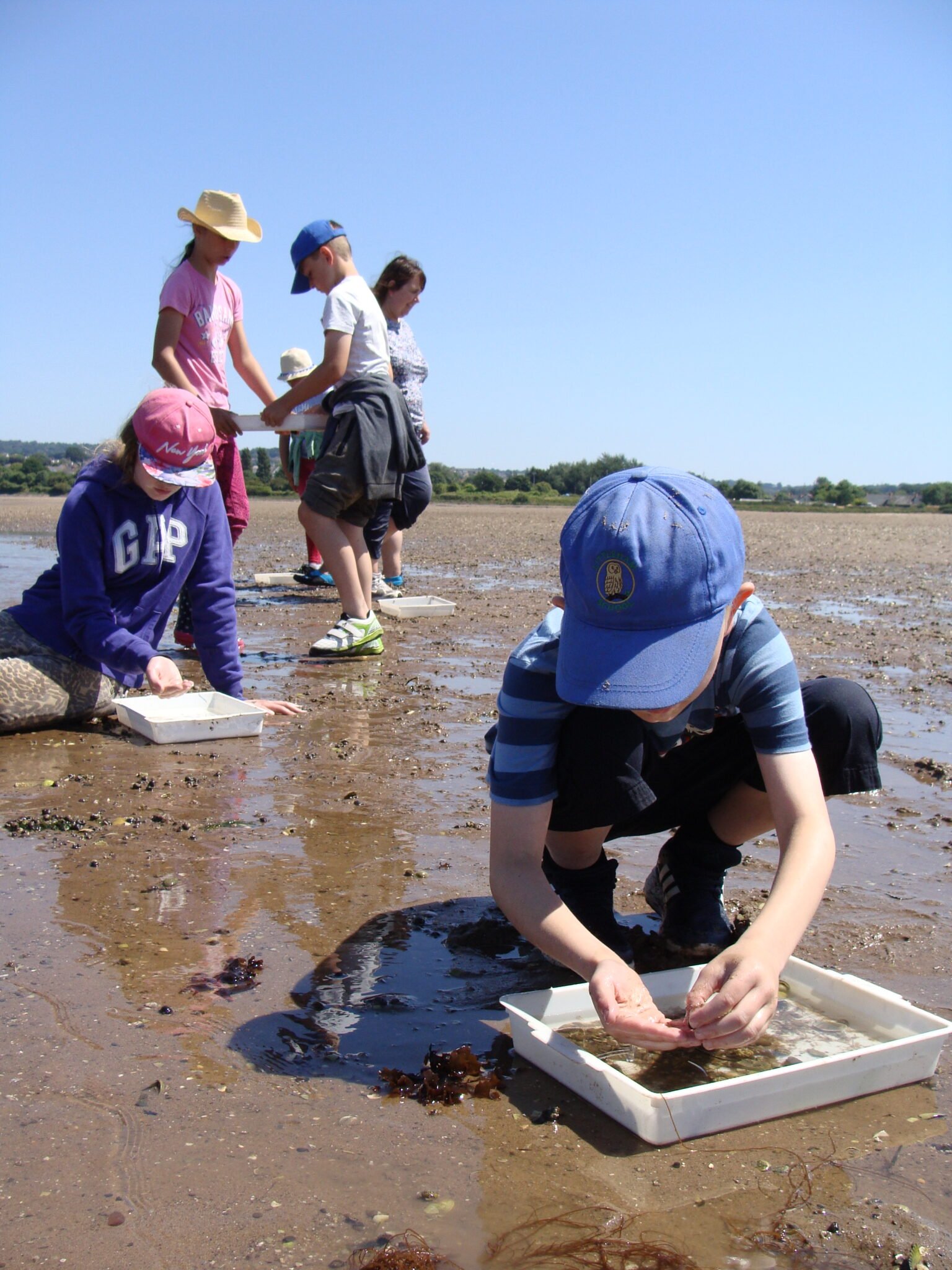
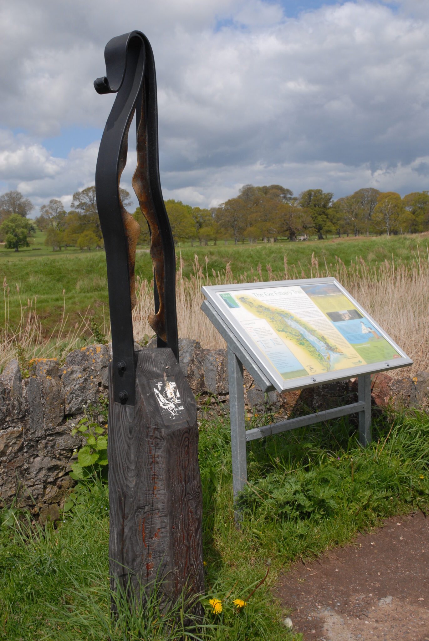
Chapter 7. Protecting the Estuary
- 7.1 Pollution Contingency Planning
The Exe Estuary is a valuable resource which supports a variety of human uses, and an impressive array of wildlife. In order to protect the estuary, it is important to be prepared to deal with events which may pose a threat. Good preparation may take the form of preventative measures, consistent monitoring and / or rapid response to harmful events. Local authorities and organisations have identified the main risks and produce a number of contingency plans which lay out the roles and responsibilities of a multi-agency response to an emergency such as a major pollution incident.
The Marine Management team within JNCC provides a 24-hour pollution response advice service for pollution incidents in the offshore area of UK waters. The National Contingency Plan (NCP) is a strategic overview for UK government responses to marine pollution from shipping and offshore installations. It sets out the arrangements for dealing with pollution, or the threat of pollution, spilled from ships and offshore installations and the responsibilities of various relevant bodies, including the Maritime and Coastguard Agency (MCA) and harbour authorities.
Devon County Council last updated its Coastal Pollution Plan in 2008, alongside booming plans for various sites and estuaries in Devon. Teignbridge District Council, East Devon District Council and Exeter City Council all have plans in place if there is an incident which link into the Devon County Council Plan and the National Contingency Plan. Other types of emergency which may occur in and around the Exe Estuary are covered by the different responding agencies’ Emergency Response Plans and the Joint Emergency Response Protocol.
Oil Spill Response
In the event of a pollution incident from shipping, the first report would come from a HM Coastguard station. They will inform the MCA Duty Counter Pollution and Salvage Officer (DCPSO) and, also in certain circumstances the Maritime Rescue Co-ordination Centre (MRCC), if they believe there is a threat of pollution. The DCPSO/ MRCC then activate the appropriate level of response. In the event of a major incident three major control centres may be set up near to the incident:
- A Salvage Control Unit – Led by the Secretary of State’s representative for marine Salvage and Intervention, who oversees and approves any salvage operation and can intervene if appropriate.
- A Marine Response Centre – Led by the MCA to co-ordinate all at sea counter pollution and clean-up operations.
- A Shoreline Response Centre – Led by the Local Authority with technical support from the MCA. This centre co-ordinates the shoreline clean-up operations.
Not all of these control centres will need to be set up in every incident and this will be dictated by the scale and type of incident.
An Environment Group may also be set up at the early stages of an incident. This group provides environmental and public health advice to the incident control centres. The Environment Group is made up of representatives of the relevant statutory nature conservation body, environmental regulator, Government fisheries department and the local health authority.
In the UK, spills are categorised by the internationally adopted tier system:
- Tier One: A small operational spill employing local resources during any clean-up. This would be managed by the harbour authority, district or city council depending on the location.
- Tier Two: A medium sized spill, requiring regional assistance and resources.
- Tier Three: A large spill, requiring national assistance and resources.
Various other organisations also have a responsibility to respond to pollution in the UK:
- Maritime and Coastguard Agency takes the lead in responding to pollution from shipping at sea.
- Ports, Harbours, Oil facilities and offshore installations have responsibility for clean-up in their jurisdictions (ports to tier 2, offshore installations to tier 3).
- Environment Agency takes the lead in responding to pollution from land based sources and would be likely to deploy the booms to protect the Exe Estuary.
- Local Authorities have accepted the non-statutory responsibility for shoreline clean-up.
- 7.2 Flood and Coastal Risk Management
Flood and coastal management aims to reduce the risks of flooding and erosion to people, property, infrastructure and the natural environment. Rising sea levels, alongside other climate change impacts including increasing frequency and severity of storms, means that coastal management will become increasingly challenging and costly. Spending public money on tidal flood defences requires a partnership approach between organisations and needs to be prioritised to protect the maximum number of people and property around the estuary.
Data published by the Met Office and Environment Agency offers projections of mean and extreme sea levels for the UK to 2300. This information is critical for long-term planning and the UK’s adaptation response to increasing sea levels. Flood and coastal erosion risk management authorities, developers and infrastructure operators all need information about the likely impacts of climate change on sea levels to incorporate appropriate levels of protection into their designs.
Flood risk combines the chance (or probability) of a particular flood happening and the impact it would have. The Environment Agency uses a probability-based model of flood risk to inform its management of flood events. Flood maps can show the two main levels of flood risk: the 100 year flood (a flood with a 1% chance of occurring in any given year) and the more severe 1000 year flood (a flood with a 0.1% chance of occurring in any given year). Higher sea levels lead to higher risks of coastal flooding and erosion, particularly if combined with stormier conditions to create huge waves, as happens in tidal surges. Tidal flood risk is increasing with climate change.
Historically, flood defence schemes, such as those protecting Exeter and other sites around the Estuary, were built after serious flood events. A problem with this reactive approach is that it does not always defend places with the greatest need. Perhaps more importantly, it only provided defence after serious flooding had occurred. With the forecast effects of climate change, the aim now is to manage these risks before they cause problems and in those places with the greatest need.
To find out if your area is at risk of flooding, check the gov.uk website. The service which provides flood maps for planning can also be used to see areas in Flood Zones 2 and 3.
Flood and Coastal Risk Management Authorities
The main authorities for managing flood and coastal risks in and around the Exe Estuary are the Environment Agency, Devon County Council, East Devon District Council, Exeter City Council and Teignbridge District Council. South West Water and Network Rail also have a role.
Central Government ensures provisions are made available for managing these risks and particularly wants a more strategic approach, with authorities working closely together to access partnership funding. The Environment Agency provides a strategic overview for all flood risk management issues and is therefore responsible for developing long term plans as well as overseeing the building and operating flood defences. It is also responsible for issuing flood warnings and ensuring public awareness of flood risk. Devon County Council is the Lead Local Flood Authority (LLFA) and has a role in co-ordinating activity across its area.
Shoreline Management Plans
Shoreline Management Plans (SMPs) are non-statutory documents which define strategic coastal defence policies over a large area and into the long term, for example over the next 100 years. The Exe Estuary is included in the South Devon and Dorset SMP, which was completed in June 2011. This covers an area from Durlston Head (Swanage) to Rame Head (Plymouth). The SMP is intended to deliver a wide-ranging assessment of risks, opportunities, limits and areas of uncertainty, and it is considered as part of land use planning. Access to SMPs can be found here.
Exe Estuary Flood and Coastal Erosion Risk Management Strategy
A public consultation on the draft strategy was undertaken in early 2013 to gather views on the proposals for new, improved and changed flood defences around the Exe Estuary and adjacent coastline. The Strategy follows on from the high level SMP and identifies appropriate schemes around the coast to put the policies into practice. It proposes an approach for each community to manage the risk of tidal flooding, whilst taking into account social, economic and environmental considerations.
In most areas the Strategy proposals are the same as those within the SMP, for example, providing improved tidal flood defences for Exmouth. However, in other areas detailed technical work has identified that a change of approach is needed. An example of this is at Dawlish Warren sand spit, where works were completed in October 2017 by the Environment Agency and Teignbridge District Council to recharge the beach with sand, remove gabion baskets and improve groynes as part of work to manage the spit increasingly in line with natural processes in the future. £12 million was spent to reduce the risk of flooding to nearly 2,900 properties around the Exe Estuary, as well as the main rail line into South Devon and Cornwall. The Exe Estuary Flood and Coastal Erosion Risk Management Strategy is available on the government website.
Options for Coastal Management
The Exe Estuary Strategy identifies what needs to be done for each estuary community in the short, medium and long terms in order to reduce tidal flood risk. It takes into account predicted sea level rise but does not identify funding. It also identifies the cost to benefit ratio of providing new or improved coastal defences and takes into account impacts on and the requirements of the natural environment.
Hard engineering options include building structures such as breakwaters, rock armour (boulders), revetments, rock filled baskets (gabions) and seawalls. These are designed to reduce wave energy whilst groynes (wooden barriers) on the beach are designed to trap sediment on the shore and stop it washing away. Other options such as flood embankments along estuaries and rivers are designed as physical barriers and require regular maintenance.
Soft options involve working with nature and can include bringing sand onto beaches (beach recharge), breaching banks to allow the creation of saltmarshes which act as a buffer, or planting marram grass to stabilise sand dunes. The choice of coastal management options for different sections of the coastline is influenced by land use, economic and social considerations, and scientific understanding.
One coastal management approach is called Managed Realignment, although this can also be referred to as ‘habitat creation’. It involves setting back the line of actively maintained defence and creating new area of intertidal habitat (e.g. saltmarsh or mudflat) on the land between the old and new defences. Depending on the situation and the requirements of the scheme the original front defence may be retained until it degrades naturally, or may be either wholly or partially removed. Managed realignment is not a do-nothing option but requires active management. This may be suggested as a response to coastal squeeze, where existing habitats are being drowned out by rising sea levels and are unable to move inland because of the presence of structures such as seawalls.
A variety of hard and soft forms of coastal defence exist on the Exe Estuary. The Exe Estuary Management Partnership includes regular articles about flood and coastal defence scheme around the estuary in our Exe Press newsletter. You can access our newsletters through our Exe Press page, or sign up for free as a member to receive these via email or post on our Membership sign up page.
Sediment Dynamics
There are complex coastal processes present within the Exe Estuary. The sediment dynamics are determined by a combination of fresh water flows, tidal flows into and out of the estuary and wave action. Dawlish Warren is closely associated with a series of sandbanks, of which Pole Sand, seaward of the spit, and Bull Hill Bank, landward of the spit, are the most significant. These features combine to provide both the estuary and the Exmouth frontage with significant protection from wave attack, coastal surges and other coast-induced processes.
It is believed that there is a circular movement of sediment in the mouth of the Exe, with limited input of sediment from either adjacent lengths of coast or from offshore. This is mainly due to the presence of the railway to the west which prevents the sea from eroding the cliffs and providing fresh supplies of sediment via the process of longshore drift. The usual circulation pattern is interrupted during storm events when large quantities of sediment can be removed from Pole Sands, Dawlish Warren and the Exmouth frontage and deposited in the channels. This shows the dynamic nature of the coastline and results in ever changing each level.
Historically the spit at Dawlish Warren has undergone periods of accretion and depletion, with movement of Warren Point also occurring. There is a significant exchange of sediment between the spit and the sandbanks, governed largely by the tides at the Estuary mouth, and resulting in fluctuations of all these features. To the east of the estuary, the beach at Exmouth also contributes to the complex sediment transport system. The beaches and dunes are sensitive to storm and tidal influences and beach levels at Exmouth and Dawlish Warren have dropped significantly over the last 15 years. There is an interrelationship between the movement of sediment at Exmouth and Dawlish which means that whatever happens at one site will affect the situation at the other. For example, there is a long-term trend of retreat along the Dawlish Warren seafront dunes, with every storm damaging the dunes – up to 5m was lost from the face of the sand dunes here following the winter 2013/14 storms.
Following completion of the Dawlish Warren Beach Management Scheme in 2017, several perceived issues have been raised regarding the movement of sediment within the estuary, mainly changes to the navigation channel including reduction in water depth, reduction in protective sand barriers to Exmouth beach front, and smothering of mud banks and mussel beds. In response to ongoing concerns raised through the Exe Estuary Partnership, the partnership collated responses from a six-week consultation and produced a report which was discussed at the March 2020 Partnership Committee meeting before being submitted to the Environment Agency for their attention. The Review of Experience and Lessons Learnt from Dawlish Warren Beach Management Scheme can be found here.
- 7.3 Spatial Planning and Development Management
Spatial planning encompasses a very wide range of issues and is guided and informed by a range of documents. Government legislation has increasingly placed an emphasis on sustainable development (including climate change), increased neighbourhood involvement and quality outcomes. Local plans must be positively prepared, justified, effective and consistent with national policy in accordance with section 20 of the Planning and Compulsory Purchase Act 2004 (as amended) and the National Planning Policy Framework.
The Exe Estuary covers four Local Planning Authority areas, each with their own local planning policy: Exeter City Council, Teignbridge District Council and East Devon District Council, whilst Devon County Council provides planning policy across the whole county (excluding the National Parks and Unitary Authority areas) for minerals and waste matters, with an adopted Devon Minerals Plan 2011-2031 and Devon Waste Plan 2014-2031.
Habitats Regulations Assessments are undertaken on emerging policies to ensure that there will not be adverse effects on the internationally and European designated sites on the Exe Estuary. Where planning policy is identified as adversely affecting the integrity of the Exe Estuary (e.g. through additional housing) financial contributions will be sought from new development towards management and other schemes to protect the area. Measures identified to avoid adverse effects are most commonly detailed in the National Infrastructure Delivery Plan 2016-2021 or local Infrastructure Delivery Plans supporting the local plan.